The Llaima volcano
 Quite close to
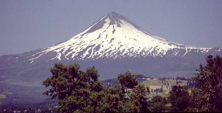
the city of Temuco, where Chile's beautiful lake district begins, the Llaima
volcano raises majestically over the surrounding landscape. It stands free,
basically disconnected from the main mountain chain of the Andes.
Quite close to
the city of Temuco, where Chile's beautiful lake district begins, the Llaima
volcano raises majestically over the surrounding landscape. It stands free,
basically disconnected from the main mountain chain of the Andes.
The Llaima is among Chile's most active volcanos. It is smoking almost
constantly, spitting some rocks now and then, and having a major eruption
several times in a person's lifetime. At a height of 3124 meters, its relatively
good access makes it possible for people with little mountain knowledge
to hike on it. There are several roads leading up to ski centers at about
the 1500m level. A well trained individual can climb the summit from there,
and return within one day.
But technically this volcano does have its problems. At mid height there
are a lot of crevasses, which can be dangerous when covered by fresh snow.
And further up it becomes very steep. The north side (where we are looking
at in this photo) ends up being about 60 degrees steep. The southern side
is easier, but requires a very long walk to reach it, forcing climbers
to camp on the slope for at least one night.
 May I introduce?
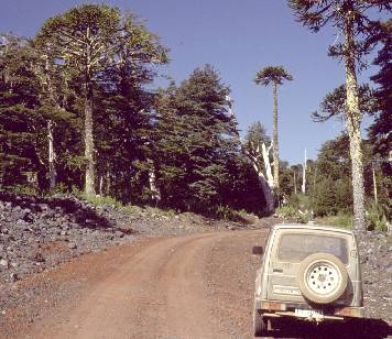
This is Mr. Suzuki. He carried me over roads and terrain, through rivers
and across snow fields, for several years, until I decided to punish him
for rattling my bones loose. I replaced my dear little Suzuki by a Nissan
Terrano, which does even better in terrain and is much more of a car, but
that's another story. When I went to the Llaima, the Suzuki did quite a
decent job in getting me high up - much higher in fact than the end of
the highest road. Mr. Suzuki hopped over boulders and through gorges, leaving
me above 2000 meters altitude.
May I introduce?
This is Mr. Suzuki. He carried me over roads and terrain, through rivers
and across snow fields, for several years, until I decided to punish him
for rattling my bones loose. I replaced my dear little Suzuki by a Nissan
Terrano, which does even better in terrain and is much more of a car, but
that's another story. When I went to the Llaima, the Suzuki did quite a
decent job in getting me high up - much higher in fact than the end of
the highest road. Mr. Suzuki hopped over boulders and through gorges, leaving
me above 2000 meters altitude.
The entire massif of the Llaima is a National Park, called "Los Paraguas"
(The Umbrellas) in honor of the Araucaria trees that grow better here than
at most places. The park has facilities for tourism, including camping
sites, hotels, etc, which are mostly located on the northern and eastern
sides of the volcano. The western and southern sides are much less populated,
and offer lots of silence and pure nature to the discerning visitor. A
road winding up through the forest, leading to several ski centers slightly
above the tree line, provides access to all this beauty.
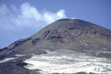
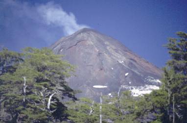 Here is a
glimpse of the northern slope, photographed through a 400mm lens from a
camping site down at the Captrén lake. Old Llaima is smoking, as
he does almost all the time. He should see all those TV adverts warning
against lung cancer. But then, volcanos probably don't care for cancer.
They have much more explosive illnesses, after all...
Here is a
glimpse of the northern slope, photographed through a 400mm lens from a
camping site down at the Captrén lake. Old Llaima is smoking, as
he does almost all the time. He should see all those TV adverts warning
against lung cancer. But then, volcanos probably don't care for cancer.
They have much more explosive illnesses, after all...
My climbing route would start from the right side of the cone, then
point towards the summit, doing the last stretch straight from front.
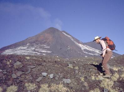 I had already
introduced my car, which is crazy enough. Now let me do something even
crazier, and introduce myself, in my modern, practical and comfortable
climbing outfit! Sorry for the strange position! The self-timer on my camera
was shorter than I thought and caught me off-guard! I made just one such
photo, so I had to use this, or none.
I had already
introduced my car, which is crazy enough. Now let me do something even
crazier, and introduce myself, in my modern, practical and comfortable
climbing outfit! Sorry for the strange position! The self-timer on my camera
was shorter than I thought and caught me off-guard! I made just one such
photo, so I had to use this, or none.
Clothing is simply normal street clothing: Jeans, long-sleeved shirt,
shoes that are lightweight but strong enough to take crampons, plus a straw
hat. This hat is comfortable, and during the time of the day when the sun
is high, it shades all of my face, ears, and neck. When the sun is low,
of course it doesn't give much shade, but the low sun doesn't bite. When
it's high it's much more dangerous. Every patch of skin that is not shaded
must be covered with sun blocker. I'm pale skinned, and if I don't use
sun-blocker, I get a nasty sun burn at this altitude. I have had some,
with blisters, fever and all, so now I try to avoid them...
The backpack contains crampons, some more clothing for the event of
bad, cold weather, photo gear (just a compact camera on this trip), a GPS
receiver, a compass, an altimeter, a VHF transceiver, a water bottle,
and something to eat - on this trip it was some bread, a piece of Huentelauquén
cheese, a tomato, an orange and a bar of chocolate.
On some trips I have tried to carry a cellular phone, but it has been
an useless effort. Cell phone coverage in Chile is still limited to cities
and the main roads, while volcanos are not well covered... Amateur radio
VHF repeaters are a very much better and much more friendly and funny way
to keep in touch with the lowly world around! From way up, there's
no real need for repeaters, as a VHF handy alone already covers a few hundred
kilometers! My record is 430 km from 3100 meter altitude, on 2.5 Watt into
a rubber duck antenna...
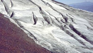
 This
is a little later. Crossing the sandy flats (well, not really flat!)
down from the first snow field is hard, hot work. So, I planned to get
onto the snow as soon as possible, and stay on it as long as possible.
Nice, baked, solid snow is better than pavement for walking on, while sand
eats up a lot of effort, and rocks make one climb up and down all the time,
also wasting a lot of energy.
This
is a little later. Crossing the sandy flats (well, not really flat!)
down from the first snow field is hard, hot work. So, I planned to get
onto the snow as soon as possible, and stay on it as long as possible.
Nice, baked, solid snow is better than pavement for walking on, while sand
eats up a lot of effort, and rocks make one climb up and down all the time,
also wasting a lot of energy.
The snow field is inclined maybe 30 degrees, making it an easy sunday-morning
walk. The loose terrain that comes after it looks more threatening...
Keep in mind that when photographing upwards along a mountain, some
of the sense of steepness is lost. Look at the volcano's smoke plume, and
you will see what I mean.
 And
this was the pavement that was waiting for me. From far away these crevasses
look like small dark lines, an could be mistaken for dust strips. But come
close, and they grow into formidable obstacles!
And
this was the pavement that was waiting for me. From far away these crevasses
look like small dark lines, an could be mistaken for dust strips. But come
close, and they grow into formidable obstacles!
The crevasses form mostly along even-altitude lines, so when you want
to climb up or down, you must walk across them, not along them. Not easy!
In this case, I had to walk along the crevasses for long stretches, to
the end of each, then switch back and walk to the end of the next... I
must have walked at least 10 km, to make just 1 km of straight progress
and gain 500 meters of altitude. That took almost three hours! But it was
still much better than rock-climbing, or wading through loose terrain,
which were the other options.
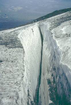 Some
people wonder how you climb out, if you happen to fall into a snow crevasse.
Hey, wake up!!! Believe me, that's not the problem! If you come to
the point of needing to climb out, call yourself incredibly lucky. The
real problem starts much before having to climb out: It is, how to survive
the landing down there. This baby is about 200 meter long, 7 meter wide
at the top, and a good 35 meter deep! A lively meltwater stream flows along
its bottom. Do you really think that you can fall into one of these...
and survive???
Some
people wonder how you climb out, if you happen to fall into a snow crevasse.
Hey, wake up!!! Believe me, that's not the problem! If you come to
the point of needing to climb out, call yourself incredibly lucky. The
real problem starts much before having to climb out: It is, how to survive
the landing down there. This baby is about 200 meter long, 7 meter wide
at the top, and a good 35 meter deep! A lively meltwater stream flows along
its bottom. Do you really think that you can fall into one of these...
and survive???
This trip was done in late summer, and all crevasses were stable, open,
and easily visible. So they were not dangerous, as long as you know where
to place your step. The problem is that in winter sometimes it snows so
much that new snow covers or even fills the crevasses. You don't see them,
you step into them, and you break through the thin snow cover and fall
to your death, or at least you sink in deeply in the fresh powder snow.
So, when doing any trip in deep new snow, always do it with
someone else, and use a safety rope. Every year several people die in places
like this, because they don't follow this basic safety measure. Those
who trek alone without the necessary knowledge and care, often simply disappear.
Sometimes they are found, several decades later, when a particularly warm
summer melts away more snow than usual and uncovers their frozen bodies.
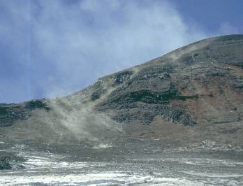 Nearing
the end of the snow field. Here the snow was much thinner, so there were
no crevasses. But a new problem arose: The large quantities of rocks coming
down from the volcano. The white cloud in the back is smoke (well, mostly
vapor), while the brownish one in the front is dust raised by rolling rocks.
Suddenly you hear them, whirring, bouncing, colliding, shattering, and
then you see them coming. Sometimes it's just one coming in your way, but
sometimes it's a few dozen! They come down almost at free-fall speed, and
any of it hitting you can be the end. There's no shelter. So, the game
is listening, looking, staying calm, and if really one of them aims
straight at you - jump aside!
Nearing
the end of the snow field. Here the snow was much thinner, so there were
no crevasses. But a new problem arose: The large quantities of rocks coming
down from the volcano. The white cloud in the back is smoke (well, mostly
vapor), while the brownish one in the front is dust raised by rolling rocks.
Suddenly you hear them, whirring, bouncing, colliding, shattering, and
then you see them coming. Sometimes it's just one coming in your way, but
sometimes it's a few dozen! They come down almost at free-fall speed, and
any of it hitting you can be the end. There's no shelter. So, the game
is listening, looking, staying calm, and if really one of them aims
straight at you - jump aside!
The Dance of the Rollin' Rocks can be quite some fun at first, but when
the volcano decides to hiccup and place you under fire for an hour at a
stretch, it can be quite tiring. After a while, you become lazy,
and try to quit the dance. Don't do that. In this day's dance I got a minor
rock against my left leg. It was just a small rock, about bullet-sized,
so it didn't break any bone, but I started leaking copious amounts of that
red juice that looks so ugly on pants and shoes...
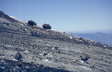 A
side view of the snow field - or what's left of it. The falling rocks have
almost covered it. Notice how the larger rocks shield the underlying snow
from the sun! As the snow around melts away, those rocks stay in place
on a socket of snow. Don't let tiredness tempt you to sit on such a rock!
At climbing time, when it's warm, often the snow socket is very soft, and
it takes incredibly little effort to set such a rock in motion! And
once it starts moving, it takes a lot of effort to stop it!
Remember: Gravity is there, and on an inclined plane like this, instability
is the only thing you can count on!
A
side view of the snow field - or what's left of it. The falling rocks have
almost covered it. Notice how the larger rocks shield the underlying snow
from the sun! As the snow around melts away, those rocks stay in place
on a socket of snow. Don't let tiredness tempt you to sit on such a rock!
At climbing time, when it's warm, often the snow socket is very soft, and
it takes incredibly little effort to set such a rock in motion! And
once it starts moving, it takes a lot of effort to stop it!
Remember: Gravity is there, and on an inclined plane like this, instability
is the only thing you can count on!
I reached the end of the snow field, and then the hardest part started.
I climbed over very soft, crumbling rock, performing the Rolling Rock Dance
once and again, until getting above the fault that was releasing most of
these rocks. There things became calmer again, and I relaxed while enjoying
a cheese sandwich with tomato accompaniment. I can tell you, at such a
moment a tomato tastes very much better than the finest chocolate! The
body is in need of liquids, and tomatoes are great at providing them! But
please, use real tomatoes, not those "Rocky" things they sell in supermarkets
nowadays, which are as long lived as rocks, and about as juicy too...
 At
the rim of the crater. A fumarole is a sure sign that this is hot terrain.
Boiling mud emits this steam plume. On such terrain you walk carefully,
always sensing if a step is safe, or if you may break through a thin crust
and poke your foot into boiling water!
At
the rim of the crater. A fumarole is a sure sign that this is hot terrain.
Boiling mud emits this steam plume. On such terrain you walk carefully,
always sensing if a step is safe, or if you may break through a thin crust
and poke your foot into boiling water!
Above the fumarole, there are signs of more volcanic activity: A small
creek must have been flowing out of the volcano there. It must have been
a boiling creek, carrying lots of minerals. The stream's bed is yellow
with sulfur deposits.
The bad thing was that the weather had decided to shut off the light.
A dense, dark cloud cover was forming very quickly, and as it formed, the
perceived temperature plummeted. I soon put on all the spare clothing I
had brought in my backpack. It feels so stupid to pack thick clothes when
at 2000 meter the temperature is 22 degrees Celsius, but up here I was
happy that I did pack some...
Then I put my backpack on again, and resumed the climb.
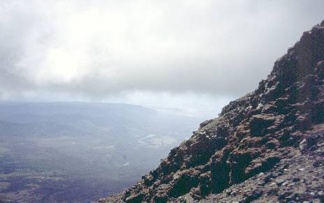 And
this is as high as I got. The end of the trip. Point of return. Location
of "too much" . Area of frustration.
And
this is as high as I got. The end of the trip. Point of return. Location
of "too much" . Area of frustration.
What happened? Well, quite simple: The slope varied between 45
and 60 degrees. The rock was extremely brittle. A step, a breaking foothold.
In between was loose volcanic dust. One step forward, two steps sliding
back. In addition, huge loads of stones, courtesy of Mr. Llaima, were being
fired at me. I grew tired and wary of dancing Rollin' Rock.
The frustration was made even worse by the fact that I was less than
20 meter from the summit! This is the very rim of the Llaima's crater.
I was just 20 steps away from peeking into mother nature's casserole, where
rocks are cooked! But simply there was no way forward, not alone at least.
Going sidewards in search for better access to the crater was no option
either, since this was the least steep place within reach...
With a friend it would have been possible, by depending on a safety
rope for a more efficient rock dance. But alone.. it would simply have
been suicide, and I knew that you wanted to read my story, so I had to
stay alive, and return to write it! So, I called it a day, rock-danced
down my way, and arrived at my car an hour before sunset.
By the way, the GPS receiver is useful! I had marked my
car's position. On return, I kept thinking that something was wrong, as I
remembered having parked my car close to a rock formation which was far away
from where the GPS pointed. Well, I was wrong, the GPS was right... When the GPS
said that only 100 meters were left to my car, suddenly it appeared in a
depression in front of me. It always impresses me anew how much different the
landscape looks from below and from above!
Back to the homo ludens andinensis page.