Flying at the Rupanco Lake
It was such a summer when I did a few flights at the Rupanco lake. But flying here is not so easy! The lake is surrounded by forest, and in most places the mountains fall off sharply into the lake, leaving no room for beaches to form.
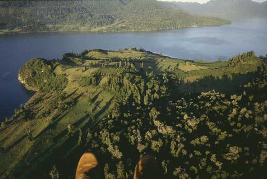
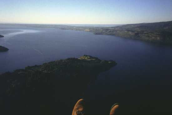
I made good use of the Ihle family's friendliness, and camped at their place for the better part of the summer. But there was no way to take off from their garden... In fact, the nearest place where I could reasonably take off was a peninsula roughly ten kilometers away. The people who own that land actually have a runway, big enough for Cessna aircraft. So, I went there, a large pack of Ihles in my wake, and not finding anyone at home, I simply set up on the runway and took off.
The peninsula proper does provide sufficient emergency landing places,
so I could cross around as I pleased. But otherwise the range of safe displacement
was very limited! Neither water nor forest make good landing sites, so
for safety reasons I had to keep within gliding range of the peninsula,
which forced me to fly high, and even then kept me confined to a relatively
small area.
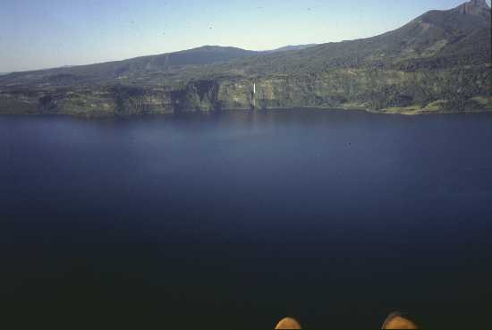 Within
gliding range of the peninsula, I also ventured over water. Here you can
see how steep the shore is! Certainly, the other side of the lake did not
offer any better emergency landing opportunities.
Within
gliding range of the peninsula, I also ventured over water. Here you can
see how steep the shore is! Certainly, the other side of the lake did not
offer any better emergency landing opportunities.
The air was quite smooth and nice, and also pretty warm. I flew a wide
spiral, getting higher with each turn, and the higher I got, the farther
I could fly out over the water, getting reasonably close to the waterfall
on the other side.
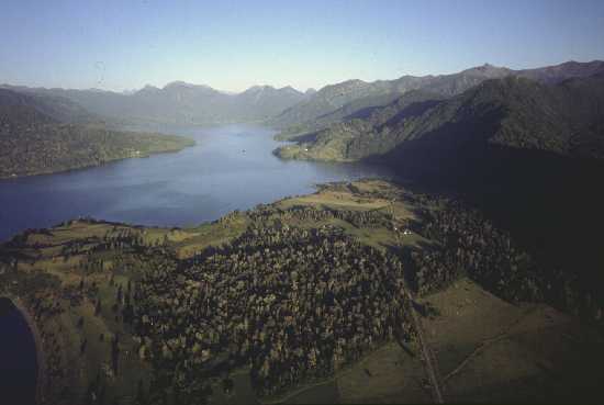 The Ihle's house
is on the right hand shore of the lake, almost at the end. I had promised
them to make an aerial photo. But it wasn't just so easy to get there!
After the peninsula, there was no safe landing site in sight for a long
stretch. The steep forest-covered hill came right to the water. So, I had
to plan on gliding back the whole distance in the event of some motor problem,
and since two-stroke engines work by Murphy's law, and always fail at the
worst possible moment, I was not willing to do away with this safety precaution.
So. I climbed, and climbed, .... and climbed! The idea was to get
enough altitude to have an assured return ticket.
The Ihle's house
is on the right hand shore of the lake, almost at the end. I had promised
them to make an aerial photo. But it wasn't just so easy to get there!
After the peninsula, there was no safe landing site in sight for a long
stretch. The steep forest-covered hill came right to the water. So, I had
to plan on gliding back the whole distance in the event of some motor problem,
and since two-stroke engines work by Murphy's law, and always fail at the
worst possible moment, I was not willing to do away with this safety precaution.
So. I climbed, and climbed, .... and climbed! The idea was to get
enough altitude to have an assured return ticket.
 While
climbing, I enjoyed the free view to the other side. The neighboring Puyehue
lake can be seen as a narrow strip under the horizon. I was around 600
meters above the terrain.
While
climbing, I enjoyed the free view to the other side. The neighboring Puyehue
lake can be seen as a narrow strip under the horizon. I was around 600
meters above the terrain.
But at this altitude I started to hit the puihua. This is a warm
wind blowing down from the mountains on the east, the same phenomenon known
as "Föhn" in Germany. It was quite smooth at this altitude, nothing
to cause any danger, but certainly it made climbing a lot harder, and there
was also another problem: The higher I climbed, the stronger the puihua
got, until at roughly 800 meters above the terrain I could no longer make
any headway! I spent a good 15 minutes parked in the air, the GPS reading
zero speed! Then I decided that of two warriors, the more clever one gives
way, and I dropped to below 600 meters, where the mountains shielded me
a little from the wind, and I had at least some ability to move around.
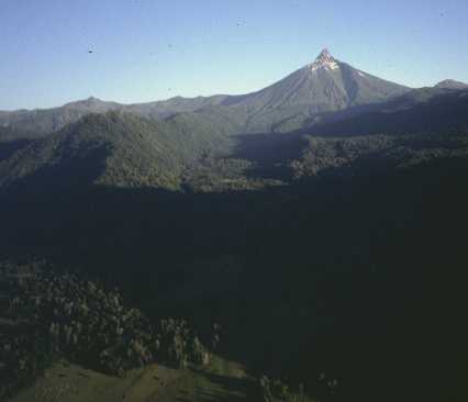 One of the prominent
features here is the Puntiagudo volcano. It means the "sharp pointed one".
You can see the origin of that name in this photo! In fact, the volcano
had an even sharper tip, but it broke off and came thundering down during
the 1960 earthquake.
One of the prominent
features here is the Puntiagudo volcano. It means the "sharp pointed one".
You can see the origin of that name in this photo! In fact, the volcano
had an even sharper tip, but it broke off and came thundering down during
the 1960 earthquake.
I was really tempted to fly closer to the volcano. A nice, beautiful
transversal valley, completely shielded from the wind, invited me to go
there. But there was one problem: Absolutely no place to land if the engine
develops any trouble. The forest is really dense here, and there are no
roads. Reluctantly, I chose the safer option of staying within gliding
distance of the landable peninsula, a decision further hardened by the
fact that I had found some oil varnish residue in the tank, before this
flight. I had cleaned the tank, of course, but one cannot know if there
was a little piece of this nasty stuff still inside, ready to clog the
fuel filter. Oil varnish loves to do that!
 It was starting to
get late. The sun was getting close to the horizon, which tempted me to
shoot this picture of the ugliest animal of all who fly. I can tell you,
it's not easy to hold both paraglider brakes plus the throttle in one hand,
stretch out the other arm holding the camera, fly straight into the sunlight,
try to aim the camera while being blinded by the sun, and then smile and
shoot!
It was starting to
get late. The sun was getting close to the horizon, which tempted me to
shoot this picture of the ugliest animal of all who fly. I can tell you,
it's not easy to hold both paraglider brakes plus the throttle in one hand,
stretch out the other arm holding the camera, fly straight into the sunlight,
try to aim the camera while being blinded by the sun, and then smile and
shoot!
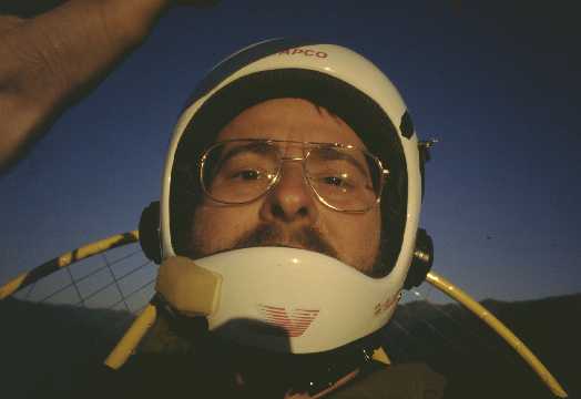
Fellow pilots and radio amateurs may be interested in the radio setup on the helmet. It's a standard free flying helmet, which I modified for paramotor use. With silicone caulk, I glued a set of Philips SBC 3142 closed-type headphones over the openings originally intended to hear the wind in the wing. How romantic... :-) But with a two-stroke engine running 30 cm behind your head, you could hardly hear the wind in the wing anyway, so it's better to close those holes and protect your hearing! The original foam padding of the helmet, which is transparent to the sound, was removed and replaced by a new padding made of vinyl, foam, and thin lead lamination. This affords about 20dB of sound insulation, which reduces the engine's noise to a tolerable, even if still not comfortable 90dBA level.
The yellow foam on the helmet's front encases a tiny electret microphone. This foam eliminates wind noise, which otherwise would make transmissions unintelligible. The engine noise interestingly is no big problem while transmitting, because it's mostly on low frequencies (under 100 Hz), so the radio rejects it! I can't hear myself at all while transmitting, but I get quite well into the radio!
On the other side of the helmet is a tiny PTT button. It came off during
setup before this flight, so it was hanging by its cable, but still worked.
I can easily reach the button during any but the most extreme flight maneuvers.
Switch, mike and headphones are properly wired to the Kenwood TH28A radio
by means of a walkman earphone cable, which has the required four conductors
while being thin enough to rupture if I ever forget to unplug it, thus
avoiding any risk of strangling myself!
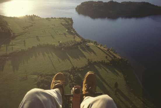 The runway is
the strip on the upper left of this photo. It is grassy, kept short and
healthy by a flock of sheep! They know flying machines, and when anything
is humming up in the air, they clear the area and forage elsewhere.
The runway is
the strip on the upper left of this photo. It is grassy, kept short and
healthy by a flock of sheep! They know flying machines, and when anything
is humming up in the air, they clear the area and forage elsewhere.
The hills start immediately to the left of the runway. At this time of the day, catabatic conditions had already set in, which lead to an interesting aerologic situation: Gerardo Ihle, on the ground, reported zero wind. Close to the runway, the catabatic flow pushed to the right. But at the altitude I shot this photo, perhaps 300 meter, I still had strong tailwind from the puihua, added to a component of it deflecting into the valley to my left, so that I had to steer right to go straight! And as if this was not enough, there was a strong local turbulence coming from the island on the right side.
I did several phantom approaches, trying to get a feel for it before
coming in for a landing. I had no big worries, after all the runway was
really big for a machine like mine, and I could afford to drift quite a
bit.
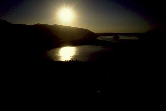 Anyway, I decided
to enjoy the sunset before landing. It's always nice to see the sun drop
out of the sky while one is still up there! As the sun got lower, some
of the turbulence died away too, encouraging me to fly some low passes,
which allowed to get the hills in front of the sun. Several pictures such
as this one resulted.
Anyway, I decided
to enjoy the sunset before landing. It's always nice to see the sun drop
out of the sky while one is still up there! As the sun got lower, some
of the turbulence died away too, encouraging me to fly some low passes,
which allowed to get the hills in front of the sun. Several pictures such
as this one resulted.
When the sun had set, I finally did my last circle and came in for the landing. I was quite low, so I used a lot of throttle to keep that altitude until I was safely over the power lines that cross the approach path, roughly 100m in front of the runway. I had to steer right quite a lot, to compensate the drift of the puihua pulling me into the valley. In the meantime, Gerardo still reported zero wind on the ground. As I crossed the valley's effect limit, the drift stopped, but moments later the catabatic flow from the hill caught me, and I had to change my heading by almost 90 degrees to the left! The turn cost me some altitude, so it looked like I would land close to the beginning of the long runway, despite having aimed for the center, where my car was. And then I sunk below the wind shear level, and started going down like a piano! The effect can frighten, but is normal, and one must sit through it and leave the flare for the last moment. So I did, and went down at perhaps 45 degrees while picking up speed. Then, almost touching the grass, I pulled the brakes, keeping 1m altitude. It was really smooth here! I kept adding brakes, while holding the altitude, until I was just next to my car. There finally my kinetic energy ran out, and gently I touched down. It came out really nice!
I was surprised to hear cheers and clapping. Mr. Kemp, the owner of
the runway, and an aviation buff himself, had returned home and found his
runway in use. He later told me that when watching me dive in at 45 degrees,
he thought for a moment that I had stalled, and was mightily relieved when
I then skimmed over the runway and came down so nicely! It must have looked
dangerous. And in a Cessna, like the one that usually lands here, that
angle surely is dangerous! Not so for a powered paraglider, which
has a very much lower surface loading and can change attitude very quickly...
Back to homo ludens volatrix.